AmbiMaster is an industrial software developed by GeoSense(Wuhan) Technology Co., Ltd. for the management, processing, and analysis of massive seismic background noise/DAS data. Based on the C++ technology platform and utilizing advanced imaging algorithms, the software possesses efficient distributed parallel computing capabilities, addressing the accuracy and efficiency issues in the processing of massive seismic background noise/DAS data encountered by scientific research and industry. It meets the scientific and industrial needs in fields such as engineering exploration, geological urvey, and oil and gas resource exploration.
AmbiMaster design highlights:
1. Based on advanced geophysical theories and algorithms;
2. Possess high computational efficiency;
3. Features convenient operation and processing procedures;
4. Efficiently output processing results.
AmbiMaster currently features the following main functional modules:
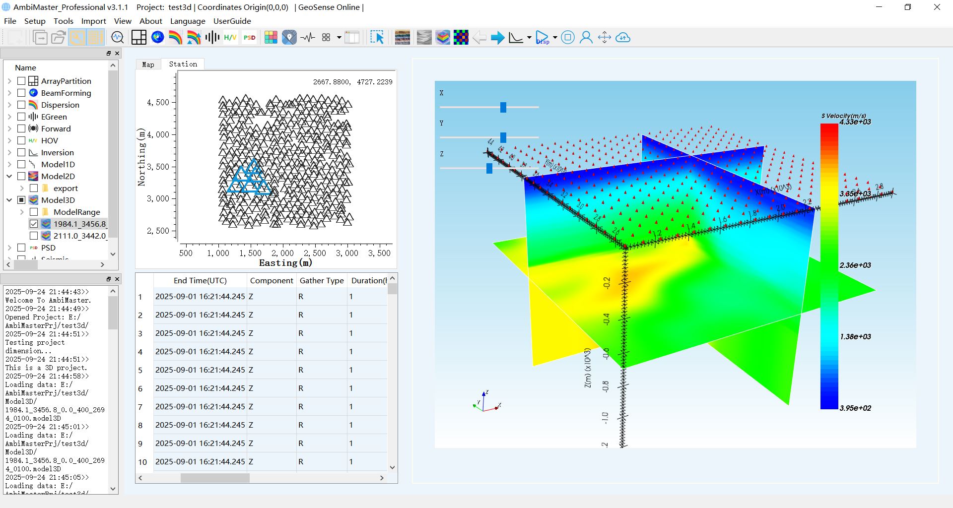
1. ESPAC 2D/3D for arbitrary array configurations;
2. Empirical Green Functions;
3. Beamforming;
4. HVSR 2D/3D;
5. PSD;
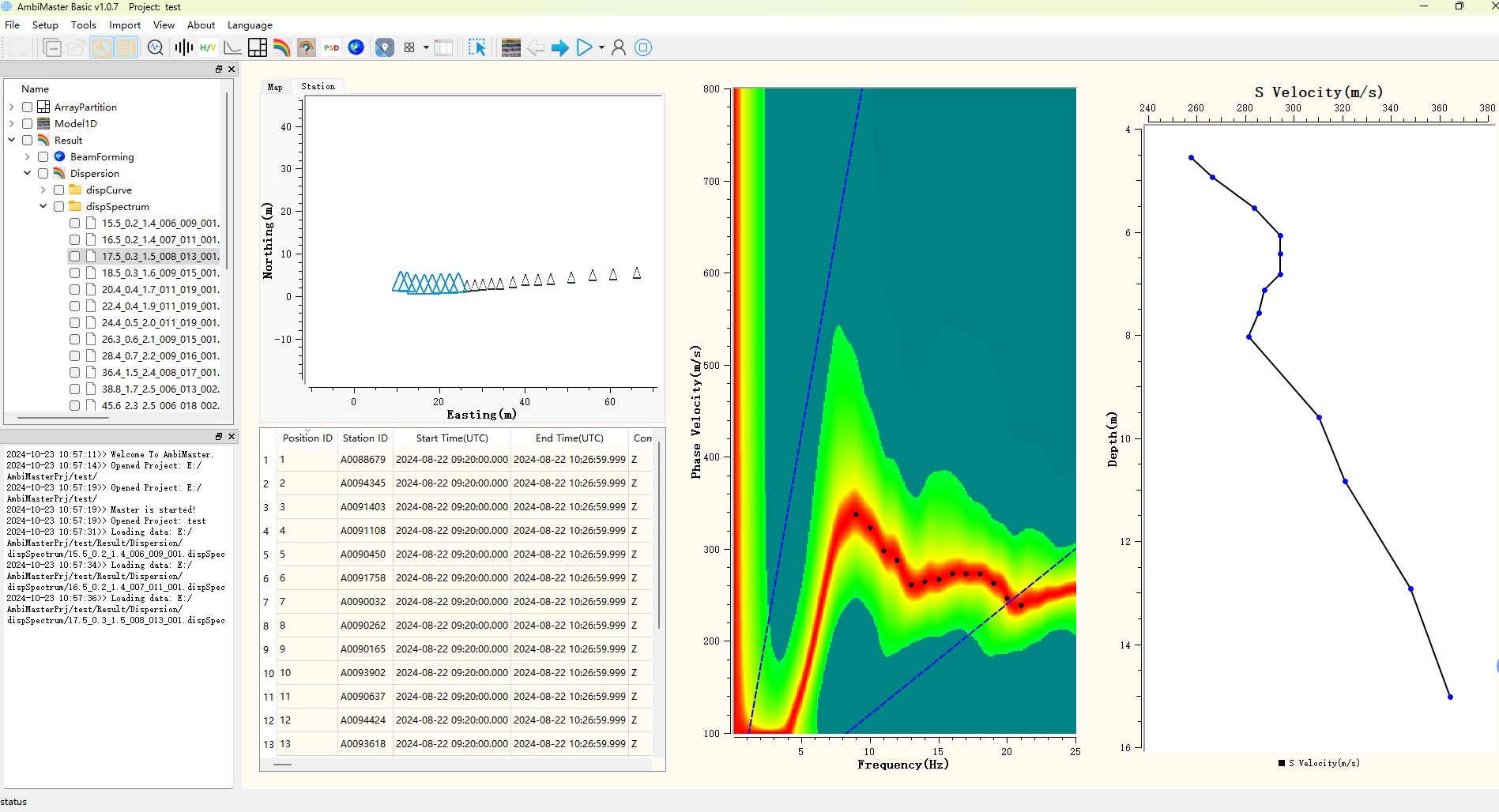
6. Double Station Correlation 2D/3D & dispersion picking;
7. One-dimensional layered model S Velocity Inversion;
8. Tomography 2D/3D based on Double Station Dispersion Curves;
9. Tomography 2D Checkboard Test.
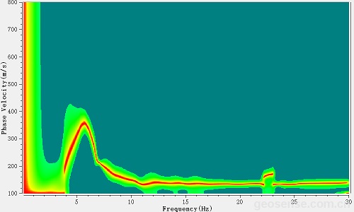
AmbiMaster improves the quality of dispersion spectrum imaging through the following auxiliary processing methods:
1. Remove near-field high-amplitude noise abnormal signals;
2. Smooth dispersion curve;
3. Data normalization (① onebit normalization, ② normalization by sliding window, ③ time domain, ④ frequency domain, any combination of the above four items);
4. Ultra-short time window dispersion generation and dispersion spectrum superposition (eliminating abnormal dispersion spectra to improve the quality of dispersion spectra);
5. Dispersion spectrum weighted superposition based on signal-to-noise ratio (simultaneously improving the focusing degree of low-frequency and high-frequency dispersion spectra);
6. Support simultaneous fitting of both the first and second kind of Bessel functions (to address interference from periodic jump fitting).
AmbiMaster enhances data processing efficiency through the following strategies:
1. Support batch calculation;
2. It supports multi-process on a single computer and distributed parallel computing across multiple computers;
3. ESPAC 2D/3D supports high-precision automatic picking of dispersion curves;
4. Multi-window picking of dispersion curves using the dual-station method (supporting simultaneous picking by multiple users);
5. "One-click" 2D/3D tomographic imaging based on dispersion curves/velocity curves, and "one-click" generation of 2D/3D velocity model maps.
Other featured functions of AmbiMaster:
1. Map display: Project the station's longitude and latitude onto a flat/topographic map;
2. Convert GNSS latitude and longitude to plane projection coordinates;
3. The seismic data is displayed smoothly in a large number of channels. Users can customize the display to be horizontal or vertical, and adjust the display density in both directions.
AmbiMaster, as a cross-platform processing software for massive seismic noise data, supports parallel computing and collaborative online work among multiple users. It is divided into two different versions:
● Basic version: suitable for all seismology practitioners, supports microtremor surface wave exploration of dozens of channels of data, and features SPAC/ESPAC dispersion imaging, H/V curves, empirical Green's function, and 2D apparent shear wave velocity mapping. Currently, users can obtain a free trial version through the official website(For non-commercial use only).
● Professional version: targeted at industrial-grade users such as engineering survey, research institutes/seismology experts, and resource and energy exploration, it meets the management, analysis, processing, and display needs of massive data at the ten-thousand-channel level. It can provide customized advanced modules. On the basis of the Basic Edition, it adds rich advanced modules such as dispersion analysis methods, noise source analysis and correction, joint inversion of dispersion curves, Love wave surface wave imaging, and 2D and 3D inversion, supporting multi-person collaboration.
For the paid version, you can apply for a trial. Please introduce relevant information in your letter (such as your affiliated work unit and contact number) and specify your technical requirements (such as detection targets and channel count). Please send your email to marketing@ambimaster.com, and we will evaluate and process your application.
The AmbiMaster software series meets diverse user needs from basic to advanced through different versions of functions and subscription models, covering noise surface wave imaging application scenarios with different depth (scale) structures. See the table below for specific functional modules.
Software version | Basic | Professional |
Target customer | All seismology practitioners | Industrial-grade users such as engineering survey, scientific research institutes/seismology experts, and resource and energy exploration |
Version purpose | Provide common data processing basic modules | Industrial-grade users such as engineering survey, scientific research institutes/seismology experts, and resource and energy exploration |
Functionmodules | 1. Data format support: SAC, MiniSEED, SEG2, SEGD, SEGY, and format conversion; 2. Spectrum analysis, filtering processing; | 1. All functions of the basic version; |
Price | Free | Pay annually or purchase for multiple years at once |
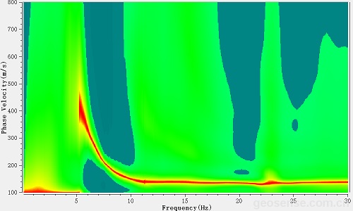
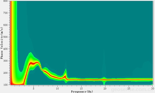
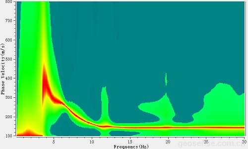
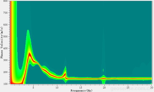
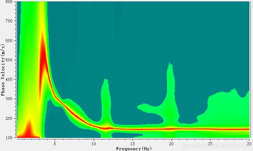
Improvement demonstration of dispersion effect
 |  |
| Eg1 | |
 |  |
| Eg2 | |
 |  |
| Eg3 | |
Left image: traditional dispersion imaging effect; Right image: AmbiMaster dispersion imaging effect
With the auxiliary processing function of AmbiMaster, the imaging quality of the dispersion spectrum can be effectively improved.
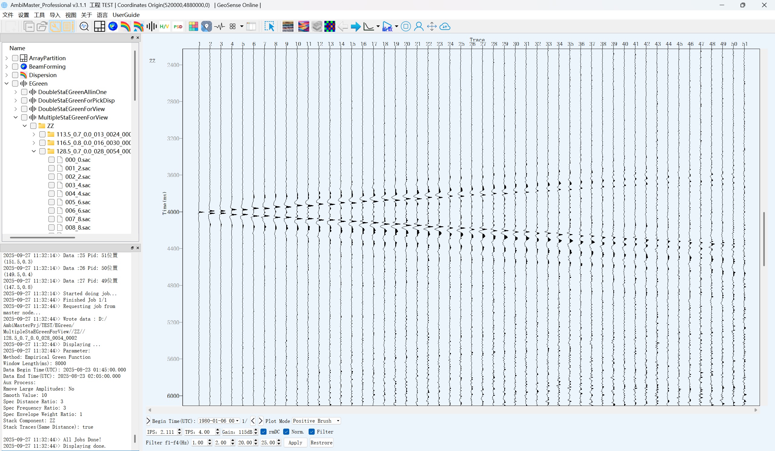
AmbiMaster Basic calculates Green's function
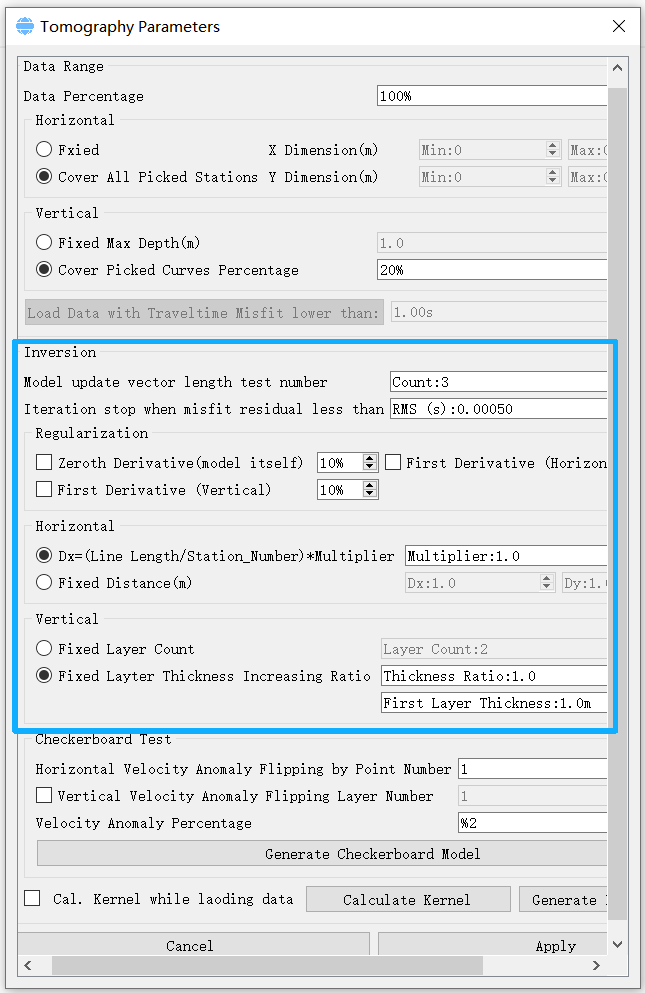
Inversion parameter setting
Model update vector length test number:
Number of iterations for step size testing. The larger this value, the more times the step size needs to be tested for each iteration, which consumes time but may yield an optimal step size. It is recommended to set it to a value less than 10.
Iteration stop when misfit...:
Iteration termination condition. When the inversion error decreases and is less than the set value, the program stops iterating. In addition, if the inversion error no longer decreases, the program will automatically stop iterating.
Horizonal:
Dx=Dy=... : The scale of the model's horizontal velocity unit is calculated based on the amount of station data and the spatial range occupied by the stations. For 3D, it is calculated by dividing the area by the number of stations and then multiplying by a coefficient. For 2D, it is calculated by dividing the length of the survey line by the number of stations and then multiplying by a coefficient.
Vertical:
Fixed Layer Count: fixed number of layers.
Fixed Layer Thickness Increasing Ratio: Fixed thickness ratio and thickness value of the first layer.
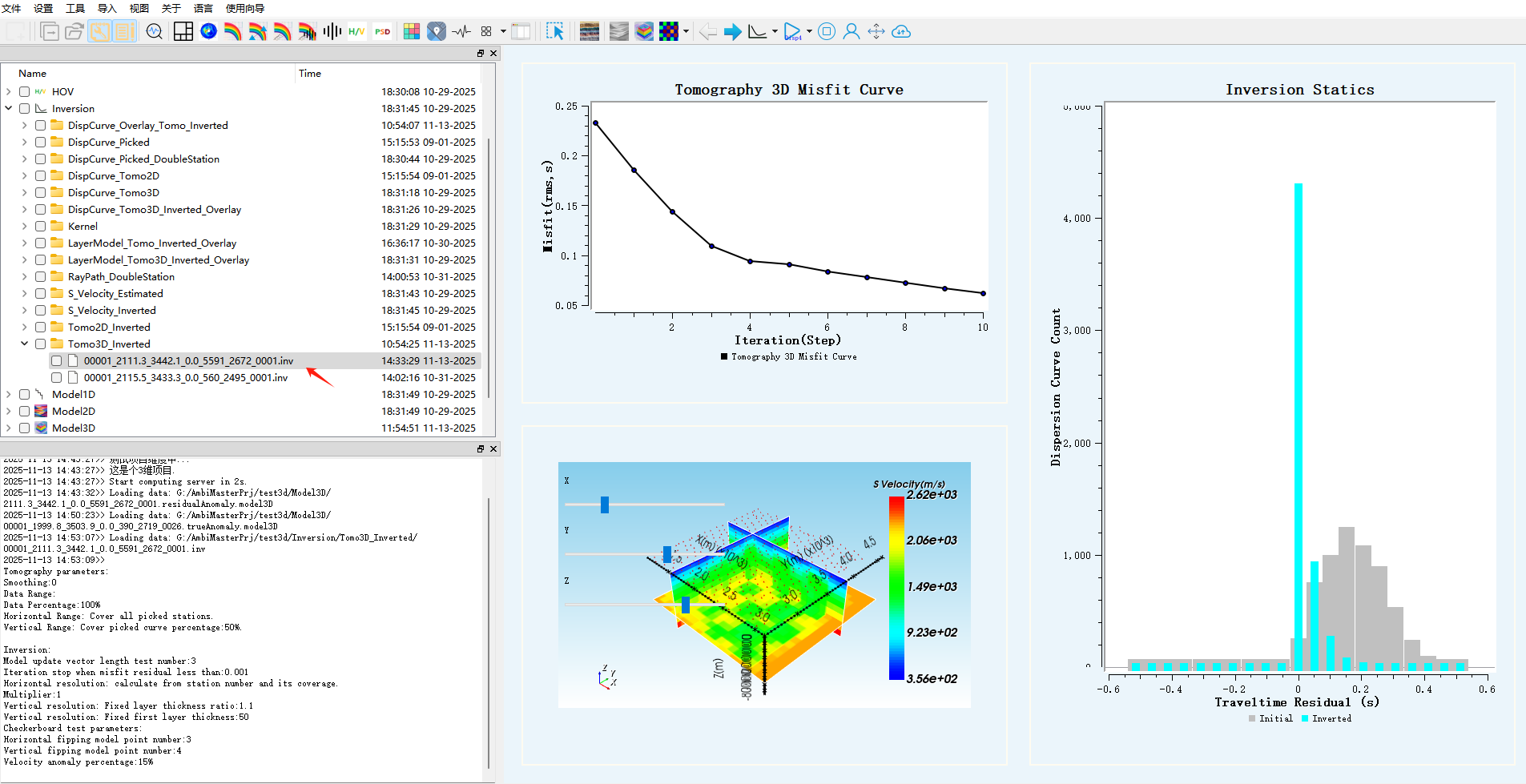
result of checkerboard test
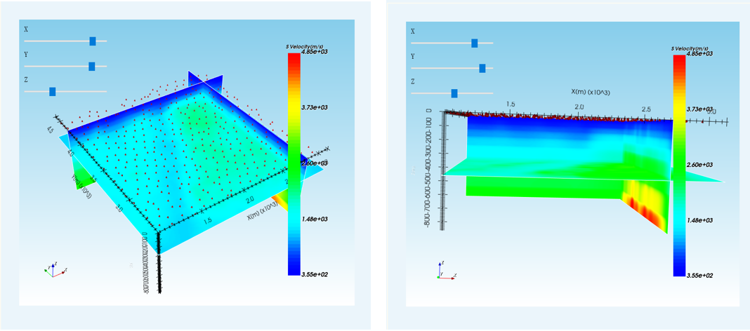
result of tomographic imaging

The results of a micromotion detection section in Qingshan District, Wuhan City show that there is an obvious lateral velocity change at a horizontal distance of about 250 meters, which may represent the location of the fault zone across Qingshan District.
For more application case demonstrations, please visit the professional version page.